Mayobridge is a hill site on the west side of the Mourne Mountains with a northwest-facing launch at 1100ft above sea level. This site provides opportunities for ridge and thermal soaring with stunning views of the surrounding Mournes. In optimal conditions, flights over the Mournes are possible.
Location: Irish Grid Reference J181262
Wind Directions: Northwest, 280 – 330 degrees (ideal at 300)
Suitable for: Hang gliding and paragliding
Pilot Rating: BHPA Club Pilots; also suitable for students
Access Information
- Road Access: From Hilltown, take the Newry (Mayobridge) Road. After about 1.5 miles, take the left fork where the main road veers right. Continue on the first left onto New Road. At the T-junction, turn right and follow the road to the car park at the hilltop.
- Parking: Park in the lay-by behind the hill.
Site Access
- Path to Launch: Access the launch area by using the gate in the fence. From there, you can either walk left around the hill or head straight over the top.
Site Rules and Hazards
- Hazards:
- Small stone walls are present at the top of the hill.
- The hill has a steep slope on the backside, posing a risk if blown over. Pilots should exercise caution and avoid getting pushed over the back.
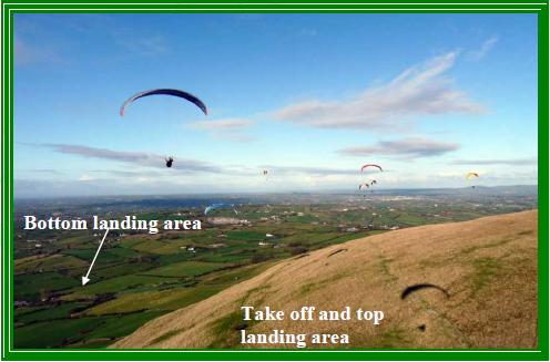
Launch and Landing Zones
- Launch: The hill has a well-rounded slope that generally offers smooth launches without major issues.
- Bottom Landing Zone:
- The primary landing area is an L-shaped field about 1/4 mile directly in front of the launch, suitable for both hang gliders and paragliders.
- Top Landing Zone:
- There is a large area for top landing. Pilots are advised to avoid going too far back, as the steep backside slope can lead to a rapid descent and hard landing. A lower shoulder to the right of the launch area offers an alternative top landing spot.
Air Traffic Control Restrictions
- None: There are no air traffic control restrictions for Mayobridge.