
Magilligan WNW, known as Hell’s Hole, is a coastal ridge site suitable for hang gliding and paragliding, positioned above the cliffs with multiple launch options around the Hell’s Hole gully.
Location: Irish Grid Reference C711328
Wind Directions: West to northwest, 270 – 330 degrees (best at 300)
Suitable for: Hang gliding and paragliding
Pilot Rating: BHPA Club Pilots; also suitable for students
Access Information
- Road Access: From Downhill, take Bishop’s Road, which climbs quickly up the cliff to a lay-by 1.5km west of the Gortmore viewpoint.
- Parking: Park in the tarmac lay-by on Bishop’s Road or close to the grass verge by the stile west of the bridge. Ensure you do not obstruct traffic.
Site Access
- Path to Launch: Use the stiles installed by the club at both parking areas; do not climb over the fence. Walk approximately 1/4 mile down to the launches on either side of Hell’s Hole gully.
Site Rules and Hazards
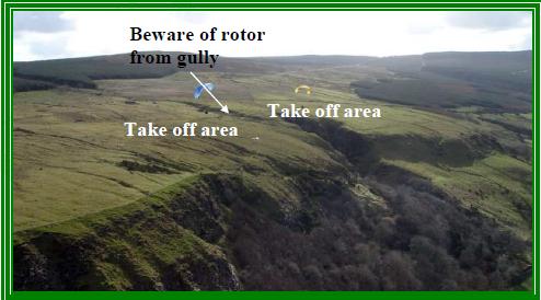
- Turbulence: Turbulence may occur at the eastern launch due to the proximity of the cliff and Hell’s Hole gully. This site may be challenging for pilots with low airtime.
- Barbed Wire: The launch area near the eastern cliff edge includes a barbed wire fence, which is a particular concern for paraglider launches.
Launch and Landing Zones
- Launch Areas:
- Recommended Launch (West of Hell’s Hole): A smooth slope located to the left (west) of the gully, suitable for all pilots, especially paragliders.
- Alternate Launch (East of Hell’s Hole): Located on a steep cliff edge near a barbed wire fence, suitable only for experienced hang glider pilots and not recommended for paragliders. Turbulence is likely in strong winds.
- Bottom Landing Zone:
- The main bottom landing field is a flat area located about half a mile in front of launch, across the road that runs below the ridge. This landing area is suitable for both hang gliders and paragliders.
- Additional Landing Options:
- A large field beside an old farm building, about 1/4 mile east of Hell’s Hole, offers an easy landing. Be cautious of the barbed wire fence parallel to the ridge and avoid overshooting due to nearby trees.
- A small sloping field directly below the launch may be used, though hang glider pilots should assess its suitability before launching.
- Top Landing Zone:
- The main top landing area is located directly behind the launch points near the road. While the area is mostly flat near the stiles, it becomes a down slope further back. Hang gliders should consider a cross-wind tracking approach, turning into the wind as late as possible on final descent.
Air Traffic Control Restrictions
- Danger Zone: Approximately 1 mile northwest of launch lies the D505/1 danger zone related to the Magilligan rifle range. Do not enter this zone.
- ILS for Eglinton Airport: The Instrument Landing System (ILS) for Eglinton Airport is located behind the ridge.
Club Procedure for Magilligan Sites
Before flying, pilots must ensure ATC has been notified of the day’s activity. If confirmation of prior contact has not been made by another UHPC pilot, call Eglinton ATC at 028 7181 1099 to advise of intended flying, noting that activity will continue until dusk. No further contact is required unless ATC requests an update.