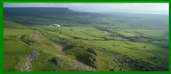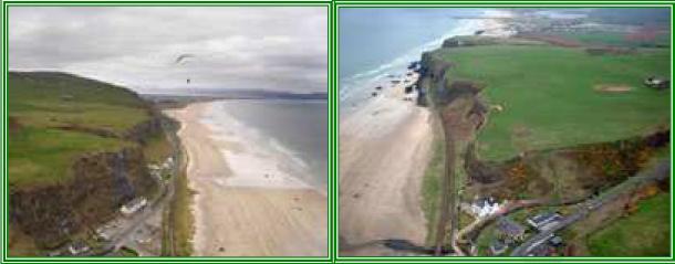
Magilligan is a six-mile-long coastal ridge that extends from the Mussenden Temple near Castlerock along the north-facing cliffs of Downhill Strand, then curves inland past Benone towards Hell’s Hole, a launch facing west-northwest. In optimal conditions, pilots can soar along the ridge up to the Binevenagh cliffs at 1200ft AMSL, which overlook Limavady. The site features two primary launch points:
- Hell’s Hole (WNW) at the western end,
- Magilligan North (north-facing) midway along the ridge between the viewpoint and Downhill cliffs.
The eastern end provides sea cliff soaring, while thermals near the viewpoint make cross-country (XC) flights possible.
Important Air Traffic Control (ATC) Notification Procedure
City of Derry Airport (Eglinton) is located southwest of the site, with an Instrument Landing System (ILS) positioned behind the main ridge. To maintain good relations and ensure safety, UHPC members are required to notify Eglinton ATC of flying activities at Magilligan, despite the airspace being Class G (uncontrolled). This voluntary notification helps ATC to inform nearby aircraft of potential gliding activity.
Procedure for Notifying ATC:
- Before any flight, ensure that ATC has been notified. If another UHPC pilot has not yet contacted ATC, call 028 7181 1099.
- Inform ATC of your intention to fly and provide the expected duration (typically until dusk).
- ATC may ask for the expected number of pilots.
No further contact is required unless ATC specifically requests notification upon finishing.
Additional ATC Considerations
ATC may sometimes respond with instructions such as “keep out of the box.” This box refers to an arrangement between ATC and the Ulster Gliding Club for sailplanes operating within the ILS vicinity, which does not pertain to paragliders or hang gliders. Clarify that you are a hang glider or paraglider pilot if needed.
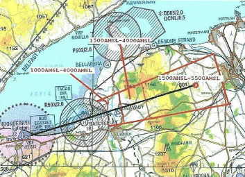
Eglinton ILS and Cross-Country Considerations
When planning XC flights that leave the ridge, be aware of potential commercial aircraft approaching from the east on the Eglinton Airport ILS. Exercise extra caution when near or crossing the ILS path due to high aircraft speeds and limited visibility from the cockpit at low altitudes. Pilots flying XC must carry up-to-date airspace information and hold a BHPA Pilot rating, or fly under the guidance of a qualified BHPA Pilot.
What is an ILS?
The Instrument Landing System (ILS) is a ground-based system that provides precision approach guidance to aircraft using radio signals and, often, lighting arrays. This aids in ensuring safe runway landings. In the Magilligan area, it’s crucial to note the ILS path (indicated as a black line on local airspace charts) and the area surrounding it, where caution is advised.