
Lurigethan is a scenic 2-mile northwesterly ridge with a cliff at its eastern end, located at the northern tip of the Antrim Glens. The launch is positioned at 1100ft above sea level. Despite its hazards, the site offers smooth ridge soaring and occasional thermic soaring in light to moderate winds, with stunning views of the Glens and the coastal towns of Cushendall and Waterfoot.
Location: Irish Grid Reference D208240
Wind Directions: Northwest, 305 – 335 degrees (optimal at 315). Do not fly in strong winds.
Suitable for: Hang gliding and paragliding
Pilot Rating: BHPA Club Pilot
Access Information
- Road Access: Drive inland from Cushendall on the Ballymena road, continuing until reaching the western end of the ridge. As the road levels out, take the first gate on the left.
- Parking: Open the gate, drive through, and park at the end of the lane without obstructing it.
Site Access
- Path to Launch: From the parking area, walk approximately half a mile up a 400ft climb to the launch (see map).
Site Rules and Hazards
- Site-Specific Advice: Pilots unfamiliar with Lurigethan should consult an experienced club pilot for detailed site analysis due to the presence of various hazards.
- Hazards:
- Spine-Back Ridge: The ridge has a steep eastern side, with dangerous rotor effects if blown back. In rising wind conditions, pilots should prioritize landing.
- Bottom Landing: The bottom landing fields are small and challenging, especially for hang gliders.
- Wind Directions: Do not fly if the wind is well off to the left of launch (i.e., west), as this can lead to severe turbulence from Tievebullagh, which is at a similar elevation to Lurigethan.
- Turbulence: Strong turbulence can occur even at moderate wind speeds (14-16 mph) on launch.
Launch and Landing Zones
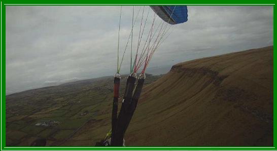
- Launch: The main launch is a rounded slope that generally presents no issues. Ground handling before takeoff is recommended to check for turbulence, as noted in the hazards section. After takeoff, pilots typically track right toward the steeper slope for better lift.
- Bottom Landing Zone:
- The designated bottom landing field is a small, flat area about half a mile to the right of launch (see map). Hang glider pilots should assess the field’s suitability for landing before taking off.
- Top Landing Zone:
- The top landing area is situated behind the launch site (see map).
Air Traffic Control Restrictions
- None: There are no air traffic control restrictions for Lurigethan.
This guide provides essential information for safe flying at Lurigethan. Pay close attention to site-specific hazards, particularly the risks associated with high winds and rotor effects.