The Knockagh Flying Site Guide
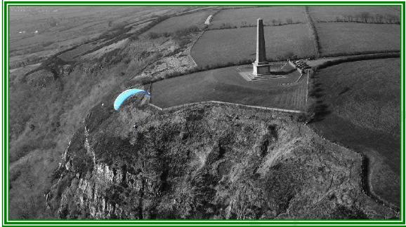
The Knockagh is a prominent 2.5-mile cliff ridge site extending from Mossley to Carrickfergus. Located above Greenisland and overlooking Belfast Lough, this site offers excellent ridge lift in light south to southeast winds due to its efficient cliff. Conveniently close to Belfast (20 minutes away), it is ideal for pilots seeking an accessible ridge soaring experience. However it has many hazards making it unsuitable for inexperienced pilots.
Location: Irish Grid Reference J365867
Wind Directions: South and southeast, 110 – 180 degrees (best at 135)
Suitable for: Hang gliding and paragliding
Pilot Rating: BHPA Club Pilot with at least 20 hours of experience
Airspace: Class D above 2000ft ALT. UHPC members can extend the ceiling to 2500ft by activating ‘Knockagh – Designated Area 3’. See the Air Traffic Control section below.
Access Information
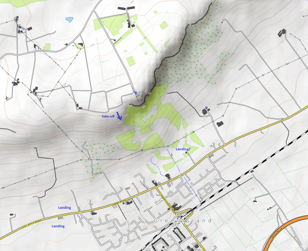
- Road Access: Access via Slievetrue Road or Knockagh Road, which runs along the back of the site. Turn uphill following signs to the war memorial.
- Parking: Park at the war memorial car park.
- Permission Note: Gavin Robinson (Tel: 07801295499), the owner of the new house, permits UHPC members to access take-off via the concrete lane, a little way back from the war memorial car park. Surrounding fields are owned by Sam Currie (Tel: 02828260133), who resides near Larne.
Site Access
- Path to Launch: Access by walking around the electric gates, then along the access road toward the landowner’s house. Avoid crossing the new barbed wire fence directly. Instead, cross the fence at a point aligned with the old path down to the takeoff zone, taking care to avoid any damage.
Site Rules and Hazards
- Air Traffic Control: Do not exceed 2000ft AMSL. There is intense aircraft activity in Class D airspace above this altitude. UHPC members can activate ‘Knockagh – Designated Area 3’ to extend the operating ceiling to 2500ft.
Hazards
- Power Cables: Numerous power cables near the bottom landing area, particularly below the lower southerly launch, create landing challenges. Downwind, additional power lines make it difficult to land safely beyond the ridge.
- Rotor: Strong rotor exists behind the cliff and can extend far back, so exercise caution when top landing.
Launch
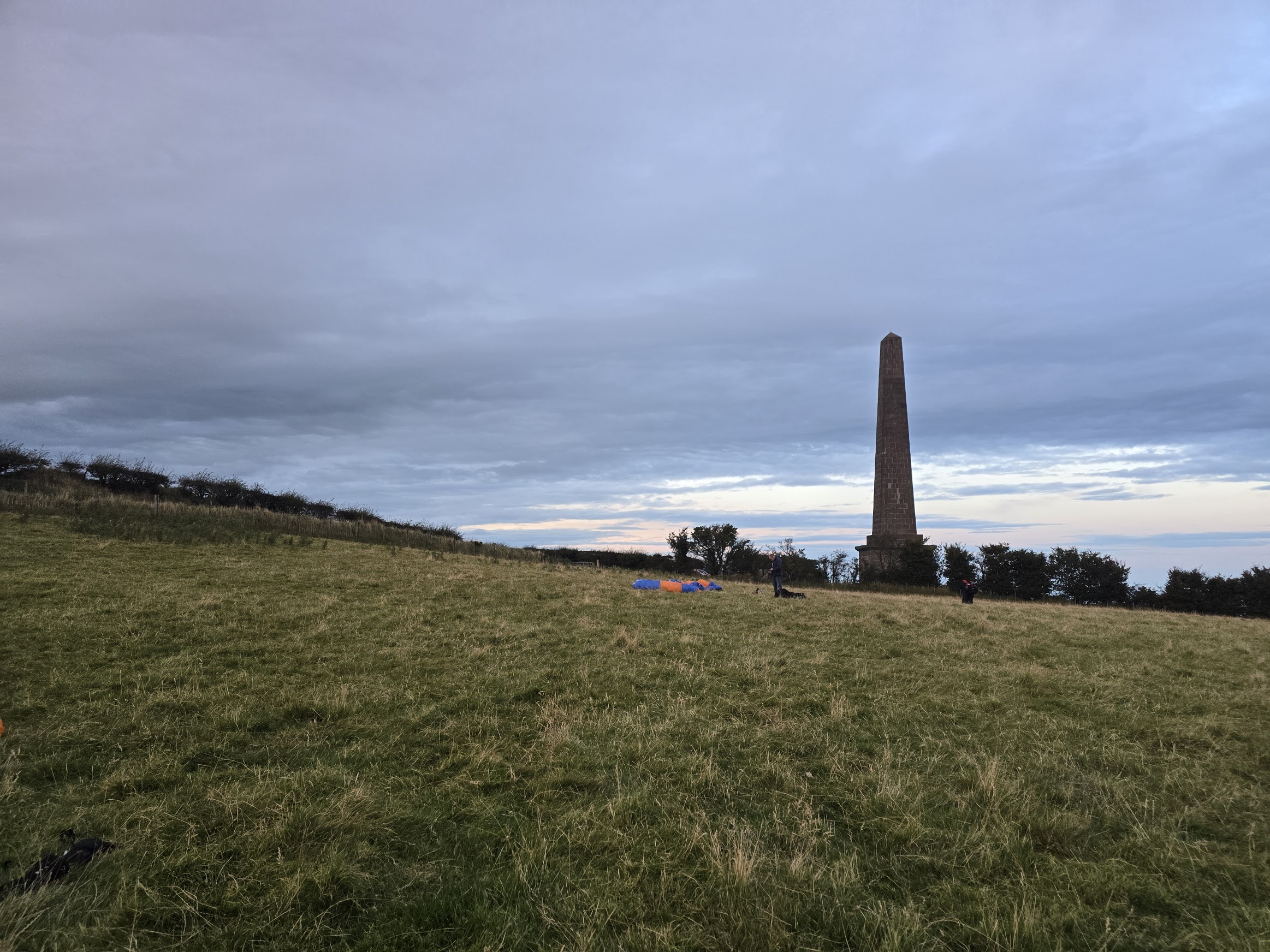
- The primary launch is located a short walk southwest of the monument, approximately 200ft lower at J365867. Carry gliders to this spot before rigging.
Landings
- Bottom Landing:
- Due to the multitude of power lines bottom landings are tricky. Do not leave it late if the lift is declining. Depart for a landing zone well before getting below take-off height. The best options are the large fields to the right of take-off (SW) but these are quite far away and enough height is needed to overfly several power pylons. Another option is in front of takeoff (SE) near the restaurant in the golf course. Again, leave the ridge with ample height to clear the electric power cables, as a conventional approach isn’t possible due to their positioning. There are other options, but check carefully for large and small power lines.
- Avoid landing anywhere near the large paddocks of the Equestrian Centre below and to the E of take-off.
- Top Landing :
- This is a cliff site and top landing is not recommended. Expect rotor, wind shear and strong wind gradients. Landings have been made half a mile behind the launch, and near take-off when winds are light.
Air Traffic Control Restrictions
- Class D Airspace: Class D airspace starts at 2000ft amsl. Aircraft on approach to Belfast International Airport frequently pass over this site. The site is part of the ‘Knockagh – Designated Area 3’ as specified in the Letter of Agreement (LOA) with Aldergrove ATC. UHPC members can activate this area and raise the ceiling from 2000ft to 2500ft by following the LOA procedures. Refer to the Designated Areas Map for specific boundaries.