Craigagh Hill Flying Site Guide
Craigagh Hill is located on the eastern side of the Sperrin Mountains, with launch situated at 1400ft above sea level. Known for its sweeping concave bowls, the Sperrins provide a unique landscape for flying, with a ridge that stretches 13 miles toward Plumbridge.
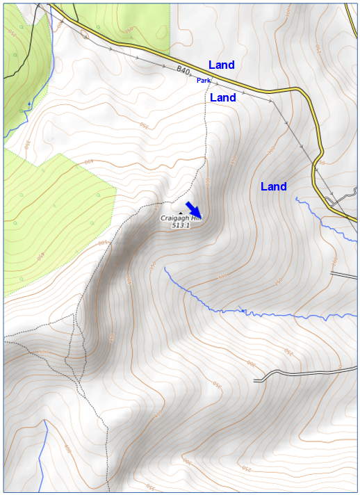
Location: Irish Grid Reference H720990
Wind Directions: East and southeast, 090 – 130 degrees (optimal at 110)
Suitable for: Hang gliding and paragliding
Pilot Rating:
- Paraglider Pilots: BHPA Club Pilot
- Hang Glider Pilots: BHPA Club Pilot with a minimum of 20 hours flying experience
Safety Notice
The local gun club operates a firing range at the base of Craigagh Hill, using high-velocity ammunition that can carry up to 3 miles. While it’s unlikely that guns are aimed toward the elevation where flying occurs, the gun club takes precautions to minimize any risk. Bottom landing options may be impacted during firing times.
- Contact: Pat Cassidy (Mobile: 07710892156, Email: creggagh@outlook.com)
- Firing Times:
- Wednesdays: 7pm to 10pm
- Sundays: 10am to 4pm
- Important: If planning to fly on Wednesdays or Sundays, contact the gun club in advance so they can be aware of your presence.
Access Information
- Road Access:
- From Draperstown: Take the B40 towards Moneyneany. After Moneyneany, fork left, drive for 1 mile, then turn onto a rough track on the left, passing under main power lines.
- From Dungiven: Follow signs to Draperstown. This route passes the White Mountain Site, then descends steeply into Moneyneany. After Moydamlaght Forest, turn right about 1 mile before Moneyneany, and then drive 1 mile to the track on the left, passing under main power lines.
- Parking: Park off the lane without blocking it. The track is suitable only for prepared 4WD vehicles, as there is deep water about 100 meters from the tarmac road.
Site Access
- To Launch: Follow the track to either the right or left.
- Right Track: Leads to a southeast-facing launch.
- Left Track: Leads to a lower, easterly-facing launch.
Site Rules and Hazards
- Power Lines: Main grid power lines run through the valley and near the bottom landing area.
- Wind Caution:
- Strong winds can lead to rotor effects behind the steep bowl and increased wind speeds near the top of the ridge.
- If flying around the ridge into the western bowl in strengthening winds, beware of the risk of being blown back into the forest.
- Some pilots have reported increased wind speeds at the ridge top, which can cause backward drift, while others maintain smooth flight in front of the ridge.
Launch and Landing Zones
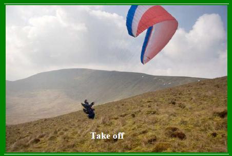
- Launch: The launch is smooth and rounded. In strong winds, launch from a forward position to avoid backward drift. See Hazards section for more details.
- Bottom Landing Zone: The bottom landing zone is directly below the launch. Be aware of the down-sloping ground and the power cables running through the valley. Refer to the Safety Notice regarding potential gun club activity.
- Top Landing Zone: The main top landing zone is located directly behind the launch area. Landing close to the road and parking area is possible but note the hazard of nearby power cables.
Air Traffic Control Restrictions
- None: There are no air traffic control restrictions for Craigagh Hill.