Slieve Gullion, a 1900ft hill site located 5 miles southwest of Newry, offers excellent ridge, thermal, and XC flying potential. This scenic area, popular among hikers and mountain bikers, has a forest drive that can be busy, especially during peak times. Permission to use this site has been granted exclusively to UHPC/BHPA members by the Newry and Mourne District Council, and specific guidelines must be followed.
Contact: James Loughran (Newry and Mourne District Council) – Tel: 07590839083. Contact to notify flying start and end times.
Location: Irish Grid Reference J017210
Wind Directions: West to southwest, 240 – 270 degrees
Suitable for: Paragliding and hang gliding
Pilot Rating: BHPA Club Pilot + 50 hours (IPPI 4)
Special Permission and Requirements
- Council Guidelines: UHPC members must carry proof of £5 million third-party liability insurance, as a Council representative may request to see this. A BHPA membership card will suffice.
- Access: Permission is granted only to UHPC members; it does not extend to other groups or individuals.
Access Information
- Road Access: Follow signs for Slieve Gullion Forest Drive from the B113 (Newry to Forkhill road), about a mile past Meigh village. Note that the drive may be closed during tree felling (check with the Forest Office at 01693 848084).
- Parking: Park in designated areas only, avoiding obstruction to other visitors, emergency vehicles, and pedestrians.
Site Rules and Hazards
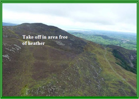
- Site Access: Avoid climbing fences and disturbing the heather. Stick to pathways wherever possible. Note: Slieve Gullion has seasonal opening times; check these to ensure you have ample time to pack up and exit before closing.
- Vehicle Identification: Each vehicle must display a card in the windscreen with the driver’s name and contact number.
- Hazards:
- Rough terrain and forest turbulence, particularly if there is a northwest wind component.
- The spine-like shape of Slieve Gullion increases the risk of being blown back in strong winds. UHPC recommends a minimum experience level of CP + 10 hours.
Launch and Landing Zones
- Launch Areas:
- Launch 1 (West Face): Located on a grassy clearing by the road, 600ft below the main ridge. It offers limited clearance over the trees and can be turbulent. Consider using Launch 2 for a safer option.
- Launch 2 (West Face): Above Launch 1, reached by a short hike and crossing a fence with a PVC pipe cover for safe passage. The route to this launch is marked by a clearing on the map.
- Launch 3 (Southwest Face): From the large car park, follow the track north to a white post marking the path to the southwest summit and cairn. Be cautious of the heather, which can snag lines.
- Alternative Launch: A take-off area exists at the northern end of the ridge, beyond the car park, though it is less commonly used. Pilots are encouraged to report back if they try this launch.
- Bottom Landing Zones:
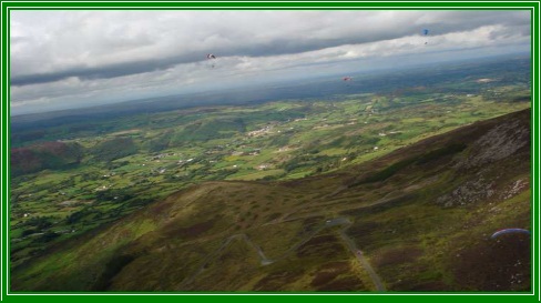
- West Face: A large, up-sloping field just to the right of a modern bungalow (J005207) is ideal for bottom landings. Approach from the northeast corner near the road to avoid power lines at the corner.
- Southwest Face: Limited landing options due to high ground upwind, which generates turbulence. Paragliders can land before the first fence on the slope; caution is advised due to the rough, sloping ground.
- Top Landing Zone: Located at the northern end of the ridge near Launch 2 or directly behind it. Be prepared for turbulence in this area.
Usage and Permissions
- Casual Flying: Permission is granted for casual use by UHPC members only.
- Organised Events: Require at least 1 month’s notice and advance permission from the Council.
Air Traffic Control Restrictions
- Dublin Airspace: Starts just south of Slieve Gullion at 4500 feet.